Steve Oudot, Inria researcher and Julian Le Deunf, military hydrographic engineer, have developed an algorithm capable of analysing seafloor mapping data. Using artificial intelli-gence techniques, this advance will simplify the work of experts responsible for creating these maps. Inria and the Lab IA, affiliated with Etalab within the inter-ministerial Directorate for Digital Affairs (DINUM), joined forces to bring about this collaboration.
Nautical charts are indispensable for all forms of maritime navigation (recreational, commercial, coastal surveillance, safety of maritime areas, etc.), allowing sailors to position themselves and navigate at sea. They are essential to navigation safety, indicating water depth or hazards in the ocean (reefs, shallow areas, wrecks, dumped munitions) and also providing regulatory information.
Nautical charts are published in France by the Naval Hydrographic and Oceanographic Service (SHOM), which is held responsible in the event of an error or accident. SHOM, a public body, also runs data collection campaigns to establish seafloor cartography. It was while participating in one of these campaigns, which mobilises the expertise of multiple hydrographic engineers, that Julian Le Deunf, data scientist at SHOM, had the idea to facilitate certain data analysis operations.
Julian Le Deunf short bio
Julian Le Deunf joined ENSTA Bretagne in 2013 and studied “Hydrography & Oceanology”, a high-level, internationally-recognised course. Graduating in 2015, he was hired by SHOM as a military hydrographic engineer. Under the supervision of Romain Billot at the LabSTICC laboratory, he is also completing a PhD thesis on bathymetric data processing, which he will defend at the end of the year.
Assisting experts in studying data
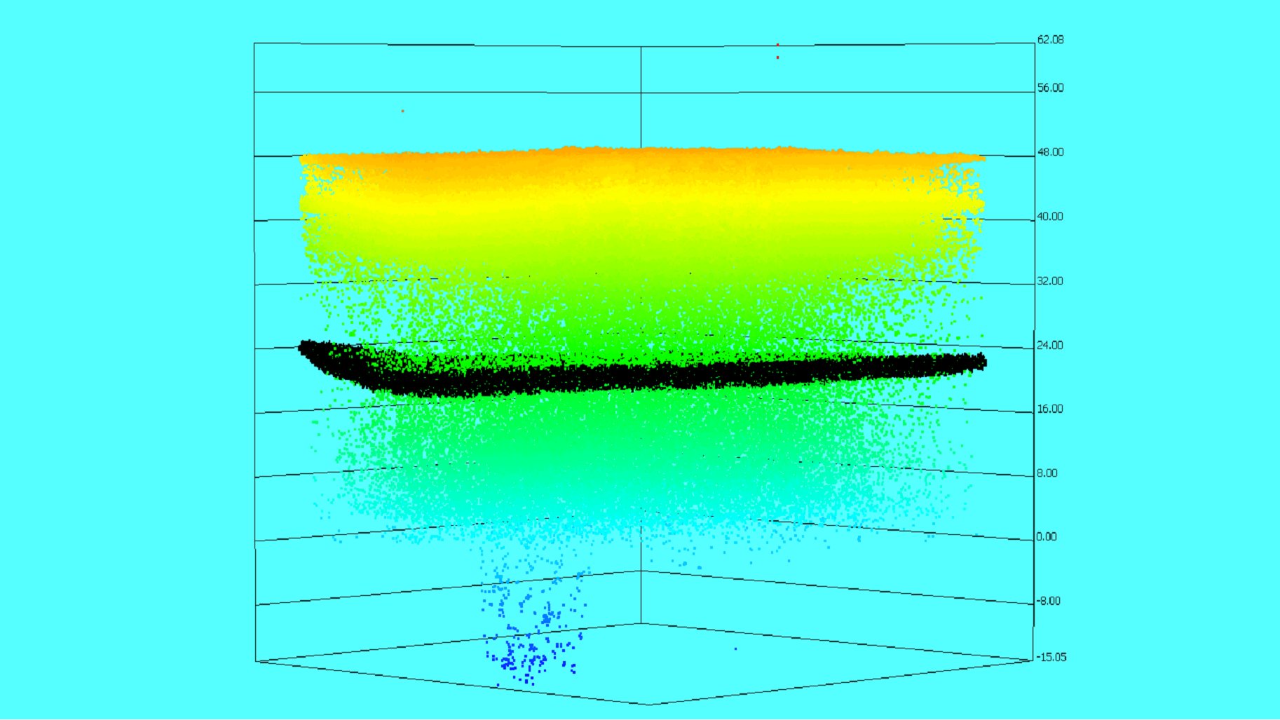
“A campaign involves analysing a large quantity of information to detect the seafloor,” he emphasizes.“Hydrographers spend several hours every day visualizing 3D data in the form of point clouds, eliminating noise and then labelling the remaining points, some representing the water surface and others the seafloor. It’s often a long, repetitive and fastidious task!” How could this work be simplified? “Artificial intelligence techniques could offer a way to assist hydrographers with these operations, by automating the identification of the simplest seafloor points and giving them extra time for more complex situations, which require their full expertise.”
The young engineer, who is working on this topic as part of a thesis at IMT Atlantique (alongside his current role), submitted a portfolio describing the planned TraitLIA project in response to a call for digital transformation projects from departments in the French government. He was placed in contact with Steve Oudot, research director at the Inria Saclay centre. “For over ten years, I have been working on mathematicaltools and topological data analysis, which makes it possible to improve the performance of machine learning algorithms and understand in detail how they work,” explains the researcher. “We were approached to offer our skills to SHOM as part of the TraitLIA project, submitted by Julian. We contributed our tools and expertise in certain artificial intelligence techniques, to adapt them to processing marine measurement data.”
Steve Oudot short bio
Research director at the Inria Saclay Centre, Steve Oudot founded the GeomeriX team in 2022, a joint project involving Inria, CNRS and Institut Polytechnique de Paris, after being a member of the DataShape team.
His career began twenty years earlier: as an engineer graduating from ENSTA Paris in 2002, he defended his PhD thesis in 2005, presenting research carried out at Inria Centre Sophia-Antipolis and École Polytechnique, on mesh generation for surfaces and varieties. He joined Inria in 2007, after two years of postdoctoral work at Stanford University (United States) where he worked on topics relating to geometric inference and reconstruction. His current research relates to data processing using topological and geometric methods.
Evaluating algorithm performance
Though using machine learning algorithms to exploit this bathymetric data does not pose any particular theoretical difficulties, it remains a new field of application for artificial intelligence. For Inria researchers and SHOM engineers, therefore, this is uncharted territory. “Our approach is unique in the way in which it formulates the problem, directly as a regression in a 3-dimensional grid, closer to the spirit of the final product (a nautical chart) than a categorisation using point clouds,” explains Julian Le Deunf. “We were then able to adapt well-known techniques from supervised learning to develop a regressive model, capable of predicting the seafloor of a marine zone using data processed for a similar zone.”
And the results look promising: “We have analysed the differences between the identified seafloor done by hand by an expert and the one proposed by the algorithm and shown that they were in the same order of magnitude as the sensitivity of measuring instruments, which is a very encouraging result.”
A positive initial report
Moreover, the methodology and tools for analysis developed for the project have been assessed by hydrographers, during two experimental campaigns. Verdict: very positive feedback, the algorithm allowed them to significantly speed up their work. This project has also allowed the team to develop operational solutions and submit the results to the scientific community, with a presentation at an international hydrographic conference and publication in a conference report.
What’s more, Julian Le Deunf and Steve Oudot are not planning on stopping after this initial state of affairs. The scientists have identified new avenues for research to push the algorithm’s current limits, for example, in its ability to generalise.
Launching more theoretical work
“As data from the Brittany coast has been used to calibrate the algorithm, it will perform well in analysing plots of this area, but will be much less efficient for the coasts of Corsica,” says Julian Le Deunf. “In the coming months, we are therefore going to launch more theoretical work, exploiting topological data analysis, with the aim of improving the performance for generalisation and understanding the variability of some of the algorithm’s predictions,” continues Steve Oudot.
For this, Inria and SHOM, joined by IMT Atlantique, have committed to a second phase of collaboration, strengthened by the signature of a research project as part of a “technical defence project”, funded by the Directorate General of Armaments. This contract will make it possible to develop a program for work across the next three years. Objective: to guarantee the tool’s maturity over time and its use by SHOM teams in quasi-operational conditions.